Mineral Resource Estimate Updated for the Cowboy State Mine Area at Halleck Creek
Highlights
-
Updated Mineral Resource Estimate in the Cowboy State Mine (“CSM”) Area reclassifies indicated resource by 68.4 million tonnes.
- 102 Channel Samples collected in 2025 provided data points for an updated geological resource model, resource conversion and mineral resource estimate
- Summer exploration and mapping collected 18 additional channel samples across the CSM area
- 18 Channel samples returned average values of 5,471 ppm Total Rare Earth Oxides (TREO)
- Standout sample (CS25-RM111) contained a new record high assay grade for the entire Halleck Creek Resource with a Total Rare Earth Oxide (“TREO”) grade of 13,816 PPM, which is 4X higher than the resource average
-
New exploration drilling permits obtained at Halleck Creek:
- 27 hole locations were permitted at the CSM area for the Development drilling needed for future technical studies beyond the Pre-Feasibility Study (“PFS”)
- 29 hole locations were permitted at the Bluegrass area, a potential exploration target which would add to total Halleck Creek Mineral Resource Estimates
DENVER, Nov. 19, 2025 (GLOBE NEWSWIRE) -- American Rare Earths (ASX: ARR | OTCQX: ARRNF | ADR: AMRRY) (“ARR” or the “Company”), is pleased to announce an updated Mineral Resource Estimate for the Cowboy State Mine area within its flagship Halleck Creek Rare Earths Project. The update incorporates the results from 18 additional channel samples and coincides with the acquisition of two new exploration drilling permits.
Odessa Resource Ltd. (“Odessa”), of Perth Australia, were commissioned to update the geological resource model for the CSM Area using 102 channel samples collected during 2025. The locations and assays for the 102 channel samples added to the geological resource model reside in Appendix B. The updated mineral resource estimate for the Cowboy State Mine area is approximately 547.5 million tonnes using a TREO cut-off grade of 1,000ppm, see Table 1 and Figure 4. The channel sample results enabled Odessa to reclassify approximately 63.9 million tonnes to the indicated category from the inferred category from the Mineral Resource Estimate presented in the February 2025 updated CSM Scoping Study1, see Table 2. Additional mapping associated with the channel sampling expanded the resource area to increase the CSM mineral resource estimate by approximately 4.5 million tonnes. It should be noted that the overall tonnage increase and change in grade do not reflect a material change to the total resource estimates for the Cowboy State Mine area.
‾‾‾‾‾‾‾‾‾‾‾‾‾‾‾‾‾‾‾‾‾‾‾‾‾‾‾‾‾‾‾‾‾‾‾‾‾‾‾‾‾
1 See ASX release dated February 24, 2025
It should be clearly noted that Mineral Resources are not Ore Reserves and do not have demonstrated economic viability. There is no certainty that all or any part of the Mineral Resource will be converted into an Ore Reserve. Areas where ARR does not control mineral resources have been excluded from resource estimates.
Table 1 - Mineral Resource Estimate for the Cowboy State Mine Area at a 1,000ppm TREO cut-off
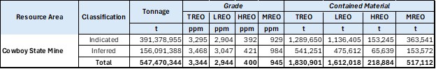
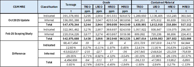
Table 2 - Differences in the Mineral Resource Estimate from February 2025 to October 2025 at a 1,000ppm TREO cut-off
In October 2025, ARR received two drilling permits from the Wyoming Department of Environmental Quality – Land Quality Division (WDEQ-LQD). 27 drill hole locations were permitted across the CSM area in preparation for in-fill drilling required for future technical studies beyond the forthcoming PFS.
In addition, 29 drill hole locations were permitted across the Bluegrass Area that has the potential to add meaningful tonnage to the Halleck Creek’s current 2.6Bn tonne resource estimate.
Why it matters? Increasing the Indicated Resource estimates at the CSM area enables near surface resources to be incorporated into pit designs and mine plans for the CSM pre-feasibility study. Stantec will integrate the updated block model with results from the ongoing process optimization work to enhance the CSM pits and mine designs. To maintain momentum and position the CSM Project for timely development, ARR is proactively securing permits for drilling and sampling to support future geological data collection beyond the PFS. Additional in-fill drilling will be required to improve geological confidence across proposed pits in subsequent technical studies.
Additional Technical Details
CSM Resource Model Update
ARR commissioned Odessa Resources Ltd. to update the geological resource model for the CSM area2. Odessa evaluated the 102 channel samples collected by ARR and incorporated them into the Leapfrog geological modeling system to update the block model for the CSM area, see Figure 4, Figure 2, and Figure 3. Based on the channel samples, Odessa converted approximately 63.9 million tonnes to indicated resources from inferred resources and added approximately 4.5 million tonnes for a total mineral resource estimate of 547.5 million tonnes in the Cowboy State Mine, see Table 1 and Table 2.
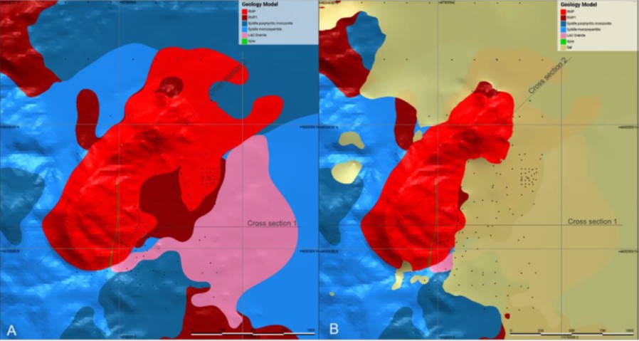
Figure 1 - Plan View of Geological Model (A colluvium excluded; B colluvium included)
Odessa, 2025
‾‾‾‾‾‾‾‾‾‾‾‾‾‾‾‾‾‾‾‾‾‾‾‾‾‾‾‾‾‾‾‾‾‾‾‾‾‾‾‾‾
2 Odessa Summary Report “Red Mountain Update Report Methodology and Resource Estimation Report”, November 2025
Figure 2 - Cross Sections of the Geological Model
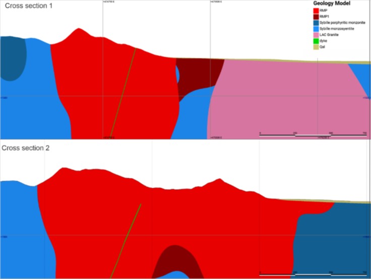
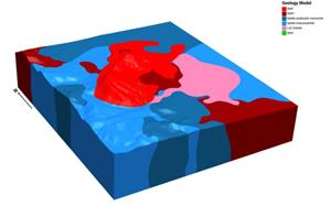
Figure 3 - Perspective View of Domain Model (1.5xVE)

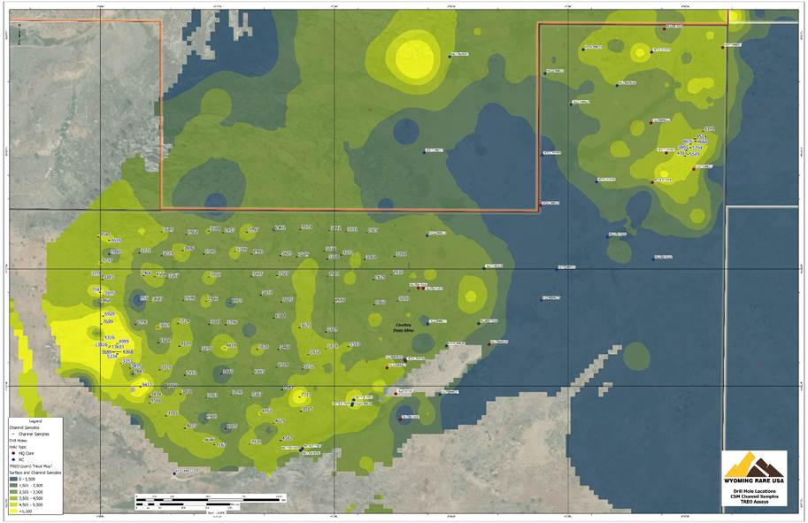
Figure 4 illustrates the TREO geochemical data from the channel samples collected across the CSM area. The channel sample results also facilitated minor changes to lithological domains within the model. This change accounts for an increase of Indicated Resources by an estimated 4.5 million tonnes, or 0.83%. Exploration results for 110 channel samples were presented in previous press releases in May 20253. The final 18 channel samples collected in 2025 are presented below.
Red Mountain Channel Samples
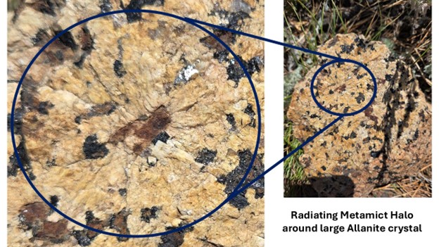
The Company’s geologists mapped a banded zone outcropping at the southwestern side of Red Mountain. 13 channel samples were collected across and adjacent to the banded zone. The average TREO grade of the 13 channel samples on Red Mountain is 5,706 ppm. This zone contains foliated mafic bands within the Red Mountain Pluton, see Figure 5. Channel samples collected across the foliated zone contain high TREO grades. One channel sample (CS25-RM111) from the zone has a TREO grade of 13,816 ppm, which is the highest TREO assay collected across the CSM area, and the greater Halleck Creek project area. The banded zone ranges in thickness between 1.5 and 3 meters and extends for approximately 250 meters along the southwestern face of Red Mountain. The banded zone plunges below surface to the south. In the same area, WRI geologists observed numerous large allanite phenocrysts (crystals) which exhibit macro-scale metamict4 structures from the allanite extending into the surrounding groundmass, see Figure 6.
‾‾‾‾‾‾‾‾‾‾‾‾‾‾‾‾‾‾‾‾‾‾‾‾‾‾‾‾‾‾‾‾‾‾‾‾‾‾‾‾‾
3 See ASX release dated May 8, 2025, and ASX release dated May 21, 2025
4 Metamict structures occur from decay of radionuclide elements in Allanite over long time periods which breaks down the internal crystal lattice of allanite and adjacent minerals.
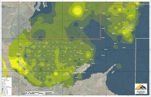
Figure 4 – Drill hole and Channel Sample Locations – Recent Sample Locations in Blue
CSM Test Pit Channel Samples
In preparation for bulk sampling from the CSM Test Pit, 5 channel samples were collected from outcrop at the test pit site. The channel samples in the CSM test pit area have an average TREO grade of 4,860 ppm. The highest TREO grade channel sample in the test pit area is 5,549 ppm.
The average Magnet REO grade for the 18 channel samples is 1,614 ppm constituting 28.5% of TREO. This also an increase of 67.6% over the modeled Magnet REO average grade of 963 ppm in the CSM area.
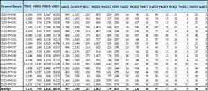
Table 3 – Channel Sample Locations and Key Rare Earth Oxide Values
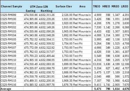
Table 4 – Rare Earth Assays of Recent Channel Samples
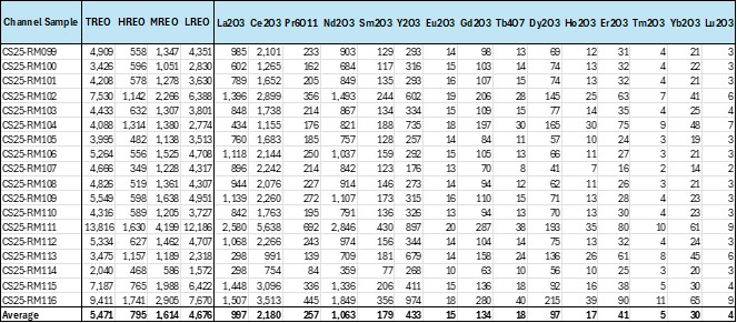
Figure 5 – Example of Localized area of foliated texture in outcrop with bands of mafic minerals from Red Mountain
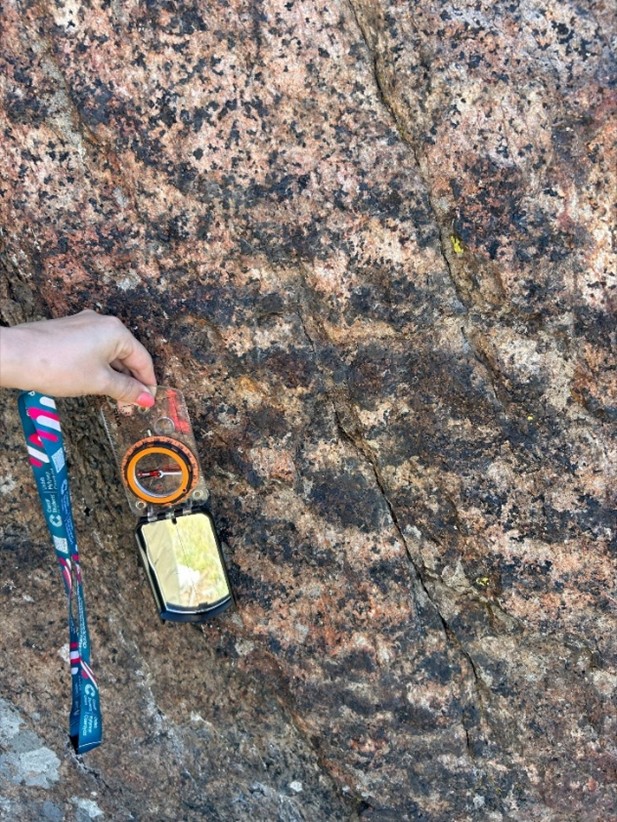
Figure 5 & 6 - Visual estimates of mineral abundance should never be considered a proxy or substitute for laboratory analyses where concentrations or grades are the factor of principal economic interest. Visual estimates also potentially provide no information regarding impurities or deleterious physical properties relevant to valuations.
Figure 6 – Example of Allanite Phenocryst and Associated Metamict Structure
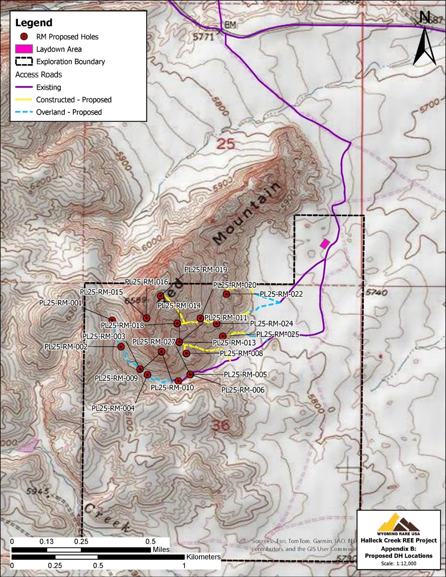
Cowboy State Mine Area Drilling Permit
The proposed drilling at the CSM area will increase geological confidence levels across the proposed pits and further de-risk the CSM leading into development work beyond the pre-feasibility study currently being drafted. The objectives of this drilling are to define substantial measured resources within the proposed pits at CSM, and to determine if higher grade zones observed from channel sampling continue at depth within Red Mountain.
The 18 channel samples taken across the CSM area will provide valuable information for the next phase of development drilling to determine hole orientations and drilling angles. The 27 permitted drill hole locations are positioned around and atop Red Mountain, see Figure 7. ARR is currently working with consulting geologists and contractors to determine optimal routes for drilling access up Red Mountain. Depending on weather and ground conditions, the construction of access trails is anticipated to commence before the end of the year with drilling planned to commence by mid next year.
Figure 7 – Proposed Hole Locations at Cowboy State Mine
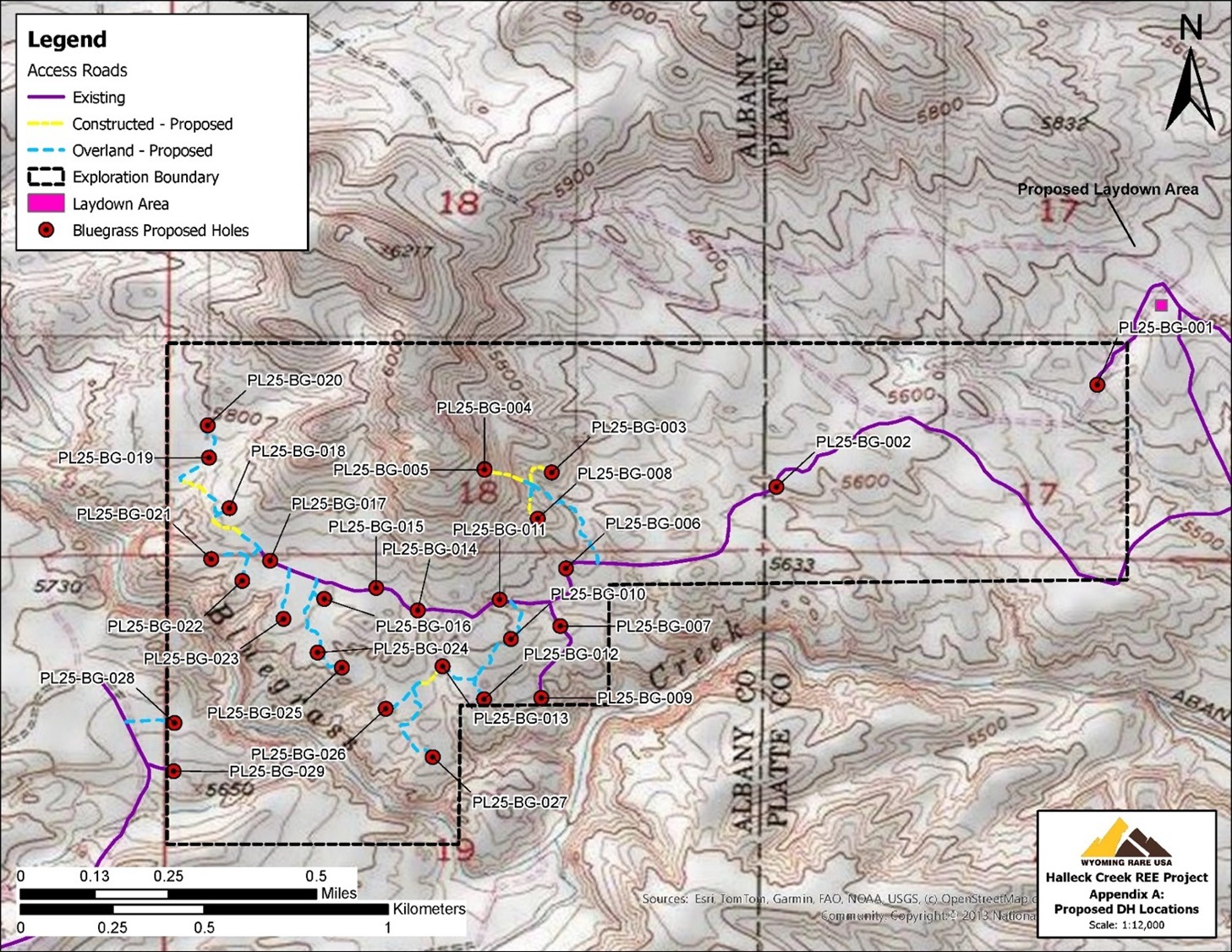
Bluegrass Exploration Area Drilling Permit
Unrelated to the Cowboy State Mine Area, locations for up to 29 drill holes in the Bluegrass exploration area have also been permitted on Federal Land where ARR controls unpatented lode claims, see Figure 8. The drilling permit will enable future exploration drilling to potentially expand the resources at Halleck Creek. Extensive surface geochemical sampling and channel sampling has been performed across the Bluegrass area. These data points indicate that Bluegrass area could have TREO grades similar to grades observed at the Overton Mountain Exploration area. The Bluegrass area has the potential to add meaningful tonnage to Halleck Creek’s current 2.63 billion tonne resource estimate.
Figure 8 – Proposed Hole Locations at Bluegrass Exploration Area
This release was authorized by the Board of American Rare Earths.
Investors can follow the Company’s progress at www.americanree.com
For further information contact:
|
Susan Assadi Media Relations US sassadi@americanree.com 347 977 7125 Full Technical report available here: |
Beverly Jedynak Investor Relations US Beverly.jedynak@viriathus.com 312 943 1123 |
Competent Person(s) Statement:
Competent Persons Statement: The information in this document is based on information prepared by American Rare Earths personnel. This work was reviewed and approved for release by Mr. Dwight Kinnes (Society of Mining Engineers #4063295RM) who is employed by American Rare Earths and has sufficient experience which is relevant to the style of mineralization and type of deposit under consideration and to the activity which he is undertaking to qualify as a Competent Person as defined in the 2012 JORC Code. Mr. Kinnes consents to the inclusion in the report of the matters based upon the information in the form and context in which it appears.
ARR confirms it is not aware of any new information or data that materially affects the information included in the original market announcement, and, in the case of estimates of Mineral Resources, that all material assumptions and technical parameters underpinning the estimates in the relevant market announcements continue to apply and have not materially changed. ARR confirms that the form and context in which the Competent Person’s findings presented have not been materially modified from the original market announcement.
About American Rare Earths Limited:
American Rare Earths (ASX: ARR | OTCQX: ARRNF | ADR: AMRRY) is a critical minerals company at the forefront of reshaping the U.S. rare earths industry. Through its wholly owned subsidiary, Wyoming Rare (USA) Inc. (“WRI”), the company is advancing the Halleck Creek Project in Wyoming—a world-class rare earth deposit with the potential to secure America’s critical mineral independence for generations. Located on Wyoming State land, the Cowboy State Mine within Halleck Creek offers cost-efficient open-pit mining methods and benefits from streamlined permitting processes in this mining-friendly state.
With plans for onsite mineral processing and separation facilities, Halleck Creek is strategically positioned to reduce U.S. reliance on imports—predominantly from China—while meeting the growing demand for rare earth elements essential to defense, advanced technologies, and economic security. As exploration progresses, the project’s untapped potential on both State and Federal lands further reinforces its significance as a cornerstone of U.S. supply chain security. In addition to its resource potential, American Rare Earths is committed to environmentally responsible mining practices and continues to collaborate with U.S. Government-supported R&D programs to develop innovative extraction and processing technologies for rare earth elements.
Photos accompanying this announcement are available at
https://www.globenewswire.com/NewsRoom/AttachmentNg/36fdee7b-668a-4722-a649-24d8c765e26e
https://www.globenewswire.com/NewsRoom/AttachmentNg/f9b65b4f-7764-4331-b1d9-09b34b7fd21a
https://www.globenewswire.com/NewsRoom/AttachmentNg/512aa69f-6d99-4d3b-be44-ad8c47b46101
https://www.globenewswire.com/NewsRoom/AttachmentNg/b9419152-1a65-4e69-8a9a-bd65186b1738
https://www.globenewswire.com/NewsRoom/AttachmentNg/21f9133c-9473-4268-8ce6-26b9f69c1770
https://www.globenewswire.com/NewsRoom/AttachmentNg/e14b0011-3a70-4517-aeff-9d398c1132b2
https://www.globenewswire.com/NewsRoom/AttachmentNg/27a86a41-bd27-45aa-ae45-a6ce9ef34e39
https://www.globenewswire.com/NewsRoom/AttachmentNg/bf075abb-7b02-4110-93da-c64230eadfe6
https://www.globenewswire.com/NewsRoom/AttachmentNg/a4fbab30-9112-4fdd-94f8-4f068ca6c20a
https://www.globenewswire.com/NewsRoom/AttachmentNg/17e2295a-5169-4c44-939e-cf52e6bd7690
https://www.globenewswire.com/NewsRoom/AttachmentNg/33e70777-1249-4a4d-8264-cf8103e188ec
https://www.globenewswire.com/NewsRoom/AttachmentNg/4b37ec73-65f4-461e-89e2-6d0172e95754


Table 1

Mineral Resource Estimate for the Cowboy State Mine Area at a 1,000ppm TREO cut-off
Table 2
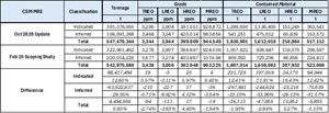
Differences in the Mineral Resource Estimate from February 2025 to October 2025 at a 1,000ppm TREO cut-off
Figure 1
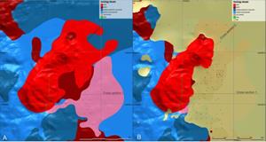
Figure 1 - Plan View of Geological Model (A colluvium excluded; B colluvium included)
Figure 2

Cross Sections of the Geological Model
Figure 3
Perspective View of Domain Model (1.5xVE)
Figure 4
Drill hole and Channel Sample Locations – Recent Sample Locations in Blue
Table 3

Channel Sample Locations and Key Rare Earth Oxide Values
Table 4
Rare Earth Assays of Recent Channel Samples
Figure 5

Example of Localized area of foliated texture in outcrop with bands of mafic minerals from Red Mountain
Figure 6
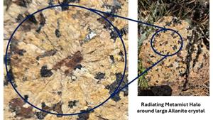
Example of Allanite Phenocryst and Associated Metamict Structure
Figure 7
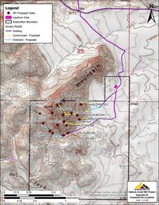
Proposed Hole Locations at Cowboy State Mine
Figure 8
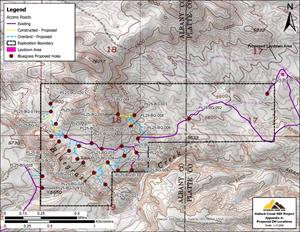
Proposed Hole Locations at Bluegrass Exploration Area
Legal Disclaimer:
EIN Presswire provides this news content "as is" without warranty of any kind. We do not accept any responsibility or liability for the accuracy, content, images, videos, licenses, completeness, legality, or reliability of the information contained in this article. If you have any complaints or copyright issues related to this article, kindly contact the author above.
